Topologia: A Strange Campaign Setting, Part 4a
- Topologia: A Strange Campaign Setting, Part 1
- Topologia: A Strange Campaign Setting, Part 2
- Topologia: A Strange Campaign Setting, Part 3
- Topologia: A Strange Campaign Setting, Part 4a
- Topologia: A Strange Campaign Setting, Part 4b
Today, Part 4a of the Topologia campaign explores the wonders – and terrors – of the Ironbarb Crags (part 1 of 2).
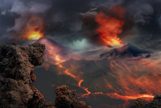
This landscape image is by Enrique from Pixabay.
Having bought myself an extra week to get it finished, I’ve decided that I really need to split this in two so that I’ve got the second part in my pocket. Why? Because this buys time for me to work on the next part in the Trade In Fantasy series – and I expect that not even this will be enough for the next in that collection of articles!
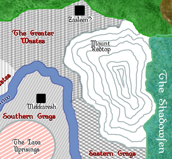
The Ironbarb Crags (Volcanic Wasteland)
The Ironbarb Crags are place of great natural beauty, desolation, and danger. Essentially a rocky desert but with some remarkable features including the mesas that give the region its name, crystal spires, a mud-flat, a cave where time stands still, the Skygorge which is an almost-perfect mirror, Mount Vertigo, a desolate region called the Directionless Void in which shadows, reflected light, and mirages make it impossible to discern true direction, Mount Optica (a dormant volcano with a lake of hot water that picks up minerals that color the water as it spills out a broken face into the Rainbow Falls) and the Dome Of Frozen Fire, an area where erosion has carved the red-and-gold rock into something that looks like flames but which is cool to the touch.
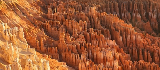
This remarkable landscape is a place called Bryce Canyon in Utah, a US National Park..Image by Pexels from Pixabay
Environmental conditions include Noxious Fumes, Acidic Rain, Flensing Dust-storms, Acid flash-floods, Lava Geysers, and Pools of hot mud.
Surprisingly. life flourishes in this desolation, if one knows where to look for it. In fact, many of its most beautiful features would not exist without that life, and the life would not exist without the harshness of the unwelcoming environment.
The experience of exploring it has been summed up as “Mud can be beautiful too”. The beauty stems from below the hostile surface, and it’s doubly-appropriate because anyone who spends too much time here becomes visibly scarred and ugly – on the surface – but most are poetic of soul and spirit. Of course, there are always a few whose exterior is a true reflection of an inner darkness necessary to their survival and prosperity in this environment.
Geographic Features of the Ironbarb
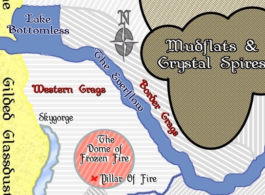
In addition to some spot extracts showing the relationships between key features of the geography, I’ve produced an overall map.
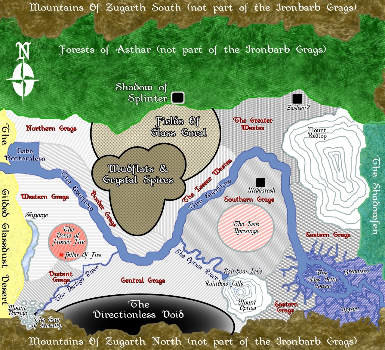
Unfortunately, that’s incredibly hard to read when it’s made small enough to fit the Campaign Mastery page. So I’ve also split into three slices:
You can also get the whole, fullsized map (1280 x 1164) by clicking on any of the four maps above.
There’s lots of information here, but I’ll get into most of it when I discuss the specific geographic features. For now, I want to cover off a couple of general items.
The Crags are divided into 11, 12, or 14 regions (depending on how you count them), plus some specific areas like the Mudflats. Each of these regions is slightly different from the others, so I’ve also given them their own feature spots below. However, while the map gives nice near dividing lines between (for example) the Northern Crags and the Border Crags, in reality there is more of a smooth transition.
Second, you may note that there’s no scale. That’s because opinions vary widely on how wide the Crags are – some say that you can reach the Everflow in a week of overland travel from Splinter, others say that it takes months. The truth of the matter is that it’s so hard to proceed in straight lines that judging the true scale is all but impossible. There’s a popular saying that the Crags are twice the size you want them to be, plus a little more just to be spiteful.
Third, Splinter is NOT where it appears to be on the map. But somehow, it is. I’ll dig into all that in more detail in the “Shadow Of Splinter” section below, which has been included even though Splinter is not shown as being a part of the Crags. You can get a foretaste of things to come by noting that Splinter is NOT in the Forest, it is to the East of the Shadowfen – which is hard right on this map. But it’s also just north of the indicated part of the Crags. And, for that matter, from Splinter, the Everflow passes through the Farms of Gardenia and the Gilded Glassdust Desert in order to enter this map on its western side!
Finally, note the mountain ranges at the top and bottom of the map. These are the same mountain range – it’s southern parts are to the North of the Crags and the Forest (which is its own Domain within Topologia) and it’s northern parts are to the South of the Crags.
This might make sense if the world were cylindrical or round – but it isn’t. And it’s daytime at the same time (more or less) throughout Topologia – there are a few hours difference, but that’s all. As usual with this place, everything makes sense until you look too closely at it – in this case, the geometry only works if there’s some sort of discontinuity at the top and/or bottom of the map, one so subtle that no-one has ever observed it.
Got your walking boots on? Let’s explore! I’m going to start west and move slowly east until I get to the end of the map..
The Sandy Line
We start with the Sandy Line, which marks the boundary between the Glassdust Desert and the Crags. At this line, there is suddenly more rock than sand, passing west to East.
But the Desert breathes like a living thing. If the winds blow from the West, the line moves somewhat East, possibly completely encompassing Lake Bottomless. If the wind blows from the East, the desert sands retreat to the west, possibly even completely off the edge of the map.
And even at the best of times, the division is somewhat subjective anyway. It’s usually the best any two or more can do to agree that past a certain point (different on any given day), you have definitely passed the Sandy Line into the Crags.
The Crags
Geologically, the region mostly consists of three things: Earth, Lava (mostly solidified), and Ferrovine deposits.
The Earth and Lava are constantly eroded by many of the climatic events that beset the region. Some events replenish the lava, and a few non-climatic processes replenish the soil every now and then, but it’s the Ferrovine that creates the numerous sharp-edged mesas and spires of rock that are literally the ‘crags’ for which the region is named.
Ferrovine is a metallic crystal. It forms veins and spires and tree-like mineral deposits. The vines and tree-like structures protect the encrusted lava and earth to some extent, creating the mesas.
Chemically, Ferrovine is a natural alloy composed of iron and chromium with trace amounts of nickel and other elements.
Unlike the lustrous sheen of noble metals, Ferrovine has a dark, almost charcoal-gray appearance, with streaks of a deep crimson or rust color (due to the iron content). When light hits it from certain angles, it can possess a faint, purplish metallic sheen.
The compound is extremely acid-resistant, which is key to the survival of the Mesas and Spires in this harsh environment (see the section on Environmental Conditions). Ferrovine is a natural alloy that can form when the right minerals in the right quantities are exposed to tremendous heat. Because of its resistance to the constant chemical assault, it has built up over time into the structures seen today.
What’s more, Ferrovine is an excellent conductor of heat, which it transfers to the magma chambers that lie beneath the surface, occasionally tipping one over the edge into ‘activity’ – to use a polite term. The depth and shape of these magma chambers varies, but all of them are comparatively shallow – enough to make digging a very risky activity. Their temperatures also vary slightly, especially where there is some natural mechanism to draw away the excess heat – so the area occupied by the Everflow is (geologically-speaking) comparatively stable, for example.
While it is incredibly strong, Ferrovine is prone to shattering rather than bending or deforming under extreme stress, contributing to the “sharp, jagged barbs” that describe the natural geology common to most of the area. Constant heating and cooling also cause stress, leading to the jagged cracks that make the crags so dangerous.
The Crags are subdivided into a number of regions, each of which has crags of a slightly different nature, as mentioned earlier. These regions (with exceptions) are labeled in red on the map to make them stand out. (For the record, a dark blue is used for water-related features and black for everything else except where white was more legible).
The Northern Crags
The Northern Crags are located north and east of Lake Bottomless, and adjacent to the Gilded Glassdust Desert. When winds blow from the west, they are polished by the sand. The presence of any non-core ingredient provides a point of vulnerability within the Ferrovine in this region, so the Crags here look like pitted glass from a distance. When you get closer, it can be discerned that more Ferrovine is exposed here than in other parts of the Crags..
The Western Crags
South of the Everflow, the area is more volcanicly active and the magma chambers are closer to the surface and hotter. The Ferrovine is exposed here, the same way that it is in the Northern Crags, but this Ferrovine is sometimes hot enough to melt the sand that strikes it. Some of that sand is then blown away (see Flensing Sandstorms in the Environmental Conditions section), but some of it clings, forming glassy trails streaming to the east from the spires and vines of Ferrovine, a frozen glass sculpture of streaming rain. The Western Crags contains Skygorge and the Dome Of Frozen Fire.
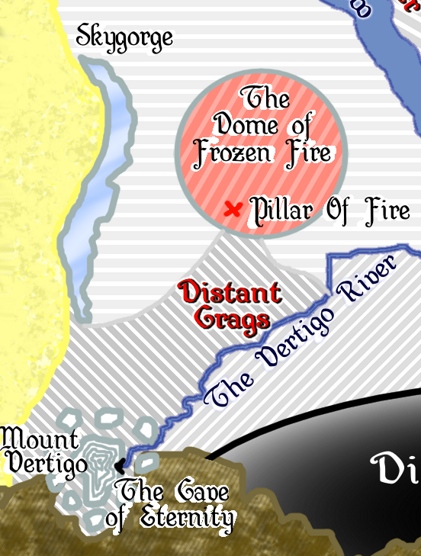
The Distant Crags
At the extreme south of the Western Crags is a region known as the Distant Crags. These are taller and more spindly, less mesa-like – javelins of Ferrovine stabbing into the air 50m (160+ feet) into the air, and typically less than a meter in diameter. The oldest and most extreme examples are located around Mount Vertigo, which also contains the Cave Of Eternity. From that cave flows the Vertigo River, which heads northeast from the edge of the Mountains, eventually draining into the Everflow. This waterway marks a natural dividing line between Crag Regions, even though the areas just east of the river still closely resemble those to its west; but this is where the crags begin to change in nature.
The Border Crags
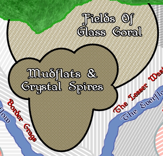
Running along the northern bank of the Everflow on the western side of the region are the “Border Crags”. They get their name by forming a natural wall along this bank of the river. The Ferrovines here are shorter than those to the west, more squat, and broader, with considerable ‘vines’ knotted between them. With the Everflow draining heat from them, this area forms a natural heat-sink that reduces the geologic activity of the area. North and east of the Border Crags are the Mud Flats and their Crystal Spires, and north of them are the Fields of Glass Coral.
The Central Crags
South of the Everflow and East of the Vertigo River are the central Crags. For some unknown reason – perhaps mere chance – the crags here are less regular and more twisted and maze-like. For the most part, these are just inconvenient, but there is a large area in their south where these structures are so bad that it has become known as the Directionless Void. The eastern boundary of the Central Crags is Mount Optica, the Rainbow Falls, Rainbow Lake, and the Optica River.
The Southern Crags
Beyond the Optica River can be found the Southern Crags, so named because they are South of the the Everflow which bends northeast as it passed the Central Crags. These crags are the most mesa-like, based around the ‘treelike’ structure of Ferrovine. North of Mount Optica, there is a region of the Southern Crags known as the Lava Uprisings, and north of that is the “City” of Mekkaresh. East of Mekkaresh, the Everflow turns sharply to the south, forming the Eastern boundary of the Southern Crags. A further boundary runs northwest from Mount Optica; the Eastern Crags are the only region located on both sides of the Everflow.
The Eastern Crags
East of Mount Optica and South of Mount Redtop are the Southern Crags, which contain the three Glass Deltas. While still hot, these areas are noticeably cooler than the other Crags, and from time to time the Shadowfen to the east floods and inundates these crags. When these floodwaters recede, they leave vast deposits of mud which quickly dries from the volcanic heat – the Eastern Crags may be “noticeably cooler” but this can be the difference between white hot and just short of red hot!
As a result, the ‘mesas’ of this region are the flattest of all, and surrounded by built-up gentle slopes of earth; mapped from above, they have the shape of teardrops with the tails pointing toward the Everflow or the Shadowfen, whichever is nearer.
The other characteristic shared by the Eastern Crags is that for a very long time, when Mount Optica erupted, its natural flow was to the East until it hit the Shadowfen, where the cooling effect of the waters there created natural walls of congealed lava, pushing the rest of the flow north. Who knows how long ago the last such eruption took place? But whenever it was, Mount Optica rebuilt that side of it’s cone to such an extent that the most recent eruption instead blew out the northwestern side of the volcano before it again became quiescent, creating the rainbow falls as the volcanic crater filled with water.
The Glass Delta – lower
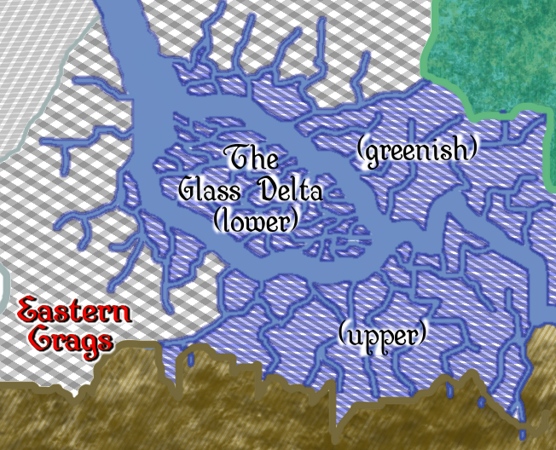
In the middle of the Eastern Crags, the Everflow divides into two channels around what used to be an island. This terrain was once probably part of the Shadowfen, but the heat from repeated eruptions of Mount Optica dried the soil of the Shadowfen and fused it into a glassy surface now known as the Glass Delta. When the surface cooled, great cracks opened up in the surface, which now form a myriad of lesser watercourses for the Everflow to pass through.
The Glass Delta is subdivided into the Lower region, the Upper region, and the Greenish Region.
The “Lower” Glass Delta is what was once an island, as explained – it gets its name for being at a lower altitude than the rest. There are thus more water channels through here than either of the other regions.
The Glass Delta – upper
The part of the Glass Delta that lies south and west of the current course of the Everflow is known as the Upper Glass Delta, so named because it abuts the mountains to the south. This region was once rolling hills protruding above the waters of the Shadowfen, but these two were covered in lava by Mount Optica, so now they are black domes of solidified lava rising above the glassy surface of the Glass Delta. The cracks in the surface thus run to but not through or over these domes, further creating the impression of large black islands on glass.
The lava domes are slowly eroding, exposing the Ferrovines in their heart, which forms a tangled knot of razor-sharp metal vines on their crests. It is safe to say that the geology of this part of the Crags is still evolving!
The Glass Delta – greenish
The final sub-region of the crags is the Greenish Glass Delta. It comes from its name in two ways – first, the glass surfaces reflect and refract the dark greens of the Shadowfen, and secondly, the glass itself here has a natural greenish tint, the result of crystallization of a vanadium-rich alloy.
One could surmise that the heat and acidic rain acted as a catalyst, changing the oxidation state of the vanadium deposits that remained. Vanadium assumes many different colors depending on its oxidation state and the configuration of the resulting crystals. Normally, many such hues are present, but the catalyzing reaction in the presence of the Ferrovine transformed the others, leaving only the +3 oxidation state, creating a distinctive green tint in the glassy surface.
The Lesser Wastes
There are two regions labeled “wastes” because they are largely devoid of Ferrovine deposits to create Crags. The first of these lies northwest of the Everflow, between the river and both the Mudflats and Fields of Glass Coral.
What Ferrovine there is present forms spires no more than 10m in height – practically dwarfs compared to the great features of other regions – and they are comparatively far apart. There are no indications as to what caused this region to be different; it’s simply an observed fact.
This is called the “Lesser” Wastes because it’s a comparatively small area, and because it’s far more crag-like and less extreme than the “Greater”:Wastes.
The Greater Wastes
North of Mekkaresh, beyond the Everflow, and between the Fields Of Glass Coral and Mount Redtop are the Greater Wastes. Despite the presence of the dormant great super-volcano to the East, the Greater Wastes – which technically should be said to include Mount Redtop – is now the least geologically-active area within the entire Crags. But this was not always the case – long ago, Mount Redtop erupted with magma far hotter than elsewhere in the Crags, sufficient for the lava flow to melt and carry away virtually all the Ferrovine in the area. This is also why none remains in the Mudflats and Fields Of Glass Coral, which some would also consider part of the Greater Wastes.
No Ferrovine, no Crags. The result in this area is a part of the crags most like a typical Rocky Desert, something which many North Americans will find familiar.
Somewhere in the Greater Wastes – possibly of no fixed location – is the Orcish power-center of Zasleen. Exactly where to find it is not known, only surmised.
With the broader geography covered, it’s time to look at the specific features that make the Crags so breathtaking – if you know where to look. The inhabitants of Topologia mostly don’t, I should add!
Again proceeding from west to east, and (generally) north to south.
Lake Bottomless
Once, this was the mouth of an active volcano, an eruption from which created the Border Crags. But it went dormant long ago, and wind/sandblast erosion from the west and being undercut by the Everflow created this unique feature. The solidified black lava of the mouth eventually subsided as the ground beneath it was cut away, eventually dropping below the surface level of the Everflow, at which point the bowl-shaped crater filled with water to become Lake Bottomless.
The lake-bed is black scoria and Basalt and virtually invisible past depths of only a foot or two. Most people assume that this is the source of the name, but the crust of the lake-bed varies considerably in thickness – in some places it is only an inch or two thick, and the unwary can find the rock beneath their feet giving way beneath them. From time to time, an opening big enough to pass through is formed or discovered, and one or two good swimmers equipped with Light spells have ventured below, discovering that the Everflow has carved out an entire additional chamber, and the apparent Lake-bed is not the bottom, after all.
Diving to the bottom of this second chamber tests the endurance of the fittest swimmers and reveals a second lava ‘floor’ just like the first – and beneath it, a third water-filled void. Few have ventured deeper, but there are reports of a third chamber below that. To all intents and purposes, this seems to be an infinitely deep series of such watery voids, and that is the true discovery for which the Lake is named..
Irregularities in the underside of the lava ‘crowns’ have left occasional pockets of air that have been unbreathed for hundreds or thousands of years. Many explorers perished attempting to replenish their breath in one of these, but they seem filled with an air that is no longer capable of sustaining life, a trap for the overly-brave.
The Dome Of Frozen Fire
There is more iron and chromium in this area that was not quite in the right proportions to form Ferrovine. These have given the Crags here a distinct reddish hue, tinged in places with yellow sand carried by the Desert winds. Erosion has carved the 20m (66 feet) tall shapes into irregular columns that twist this way and that, looking for all the world like flames that have somehow solidified.
The Pillar Of Fire
Near the southern edge of the Dome Of Frozen Fire is a pillar of flame created by a leaking combustible gas from the ground beneath which has somehow ignited. The pillar seems to be supported by an inexhaustible supply of fuel, and is a perpetual feature of the Crags. Should you step into the flame and survive, you will find yourself to be somewhere in the Desert far to the west of where you were.
Skygorge
Once a natural valley, a rent in the ground, this filled with sand from the desert – sand that was fused into a perfect mirror of glass by an eruption from Mount Vertigo long ago. Initially covered by igneous rock, but this was less resistant to the erosive forces of the Crags and over time, this incredible feature was revealed. Running in a general north-south orientation, there is little sign now that Mount Vertigo was ever a volcano, leaving the creation of this natural wonder a mystery. But this is the only explanation that has been put forward to explain the creation of this phenomenon.
Mount Vertigo
Mount Vertigo was once a volcano whose lava tapped into a vast reservoir of molten Ferrovine stretching vertically to the mouth of the volcano in an almost perfectly-straight column. And then the volcano became dormant, and the basalt around it (mostly) eroded away, leaving nothing but this enormous spire jutting skyward more than 500m (1640 feet). The sides appear perfectly smooth. Only near the base do the sides flute outward because of the main lava chamber (also frozen into crystalline eternity).
It is possible to get within a handful of meters (10 feet) of the base of the needle-shaped pillar. Those who do so are often overcome by vertigo if they look up at the top of the spire, hence its name.
Impurities within the crystals give the mountain a vibrant multicolored appearance that instantly draws the eye.
The multi-hued vibrancy of Mount Vertigo, with two of its Guardians.
An observer once stated, “It was as though I was being ordered to follow the spire from base to tip by the Mountain itself. Of course, when I did so, I became dizzy and disoriented and almost fell onto the shards underfoot – yet I could not look away.”
The Guardians Of Mount Vertigo
Lesser only to the colossus of Mount Vertigo itself, these nine spires surround the mountain and frame it. Visually similar to Mount Vertigo itself, which makes them stand out in comparison to the normal crags.
The Shards
Once, the sides of Mount Vertigo and its Guardians had branches twisting this way and that, but these could not support their own weight and fell, shattering into uncounted millions of shards from an inch to 10 inches in length. These crunch underfoot as one walks in the vicinity, your feet sinking up to a foot deep as they compress under the load. Their points and edges are razor-sharp and can cut footwear – and feet – to ribbons. Falling onto them is a really bad idea.
The King and Queen of Dragons
It is rumored that Draconic colors represent a hierarchy within Dragon-kind: Gold, Silver, Blue, Black, Bronze, Red, White, Brass, Green, Brown. As one gets promoted through the hierarchy, one sheds its skin to emerge with a new coloration and a new mental state. But it’s just a rumor. It is also rumored that the King and Queen of dragons make their home at the top of Mount Vertigo. No-one knows whether or not it’s true.
The Cave Of Eternity
Almost as fantastic as the spires that tower above it is the Cave Of Eternity, located on the Eastern face of Mount Vertigo. Inside, time seems to stop – when you emerge, what seemed like moments turn out to be hours, what you thought were minutes were the passing of days. The tinkling of water, accompanied by the occasional deeper-noted drip, are a naturally-occurring music that can be mesmerizing, and for many years it was thought that this accounted for the effect – until someone stuffed their ears with cloth to muffle these sounds and found it to be undiminished.
Some now think that there is a monster who dwells within, feasting on the thoughts of those who enter, creating the impression of time passing you by, but this is contradicted by the facts – first, no such monster has ever been found, and second, physical processes – the need for food, water, sleep, etc – seem to be slowed as much as awareness of time. If this were purely a psychological phenomenon, that would not be the case.
So it’s just a strange and magical place with no explanation.
The Vertigo River
The Vertigo River (named for the Mountain) carries water from the mountains through underground aquifers to emerge above ground from the Cave Of Eternity. Trace minerals encountered during its passage through the crags makes it increasingly acidic as it flows toward the Everflow, becoming most concentrated at the point where it juts northward before turning more easterly once again.
The Directionless Void
Glass can bend and reflect light, and in this region, reflections, distortions, and mirages make it impossible to discern east from west, north from south. Adding to this effect are the maze-like gaps between the outcroppings of Ferrovine that are a feature of the surrounding Central Crags. Once entered, only chance can permit egress from this region of captivating and deadly beauty.
The Mudflats
A vast lake of mud, constantly heated from below – more intense in some places than others – this region contains some of the most complex biology anywhere in Topologia, completely hidden from view. The mud – or, more accurately, the liquid that makes it mud – is both acidic and toxic to humans, humanoids, and most other species, though Black Dragons have been known to bathe in it.
While these will occasionally accost those traveling on the nearby Everflow, for the most part they are too arrogant to bother interacting with lesser creatures unless provoked. Some scholars content that the acidic breath weapon of this variety of dragon-kind is a purification of the liquid within the Mudflats and not a completely natural ability inherent to the species.
Rising above the mudflats are the towering Crystal Spires. Floating, partially submerged in the mud, are Mire-Blooms surrounded by Spectral Shards. Mire-Blooms are dome-shaped fungi up to a foot in diameter. Sometimes, there is only enough room in a mud pool for one of these plants, sometimes there may be several clustered together.
Spectral shards are flat panels of crystal that float on the surface of the mud. Their size is proportionate to the size of the mud pool and the individual Mire-Blooms of that pool, and it was long recognized that this implied some connection between them; the fact that the blooms are always surrounded by a ring of these floating panels deepened the suspicion. Relatively recently, it was deduced that they are a byproduct of the Mire-Blooms. I’ll talk a lot more about all of this when I discuss the Mire-blooms in the section on Plant Life.
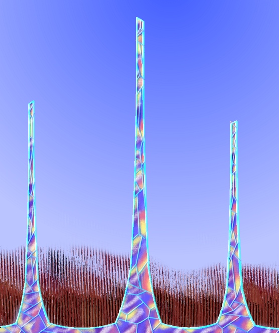
The Crystal Spires
Emerging from the mud-pools are quartz-like crystalline spires with a structure that reminds most of overlapping scales. For the most part, these are translucent, almost glass-like, but through their center runs a multi-hued spine that forms when the spire grows thick enough. It was obvious from the moment these were discovered that they are constructed from, and somehow related to, the Spectral Shards, one of which forms an individual “scale”, but the processes involved took a long time to be deduced. See “Sun-eater Moss” in the section on Plant Life for more on the Spires and their characteristics.
The Fields Of Glass Coral
At the base of the Crystal Spires, buried beneath the mud, are another plant species, or maybe they are an animal species – opinions vary – called Glass Coral. When the mud dries out, it recedes to beneath the surface of the Glass Coral, and any thin coating that remains is quickly eroded away, a process that can take only days or weeks (depending on the season and the conditions). This exposes the Glass Coral and destroys the Crystal Spires save for the roots of the spires that lie beneath the tops of the Glass Coral.
Picture a beautiful coral reef, resplendid in multicolored perfection, a myriad of forms and shapes. The montage below should assist:
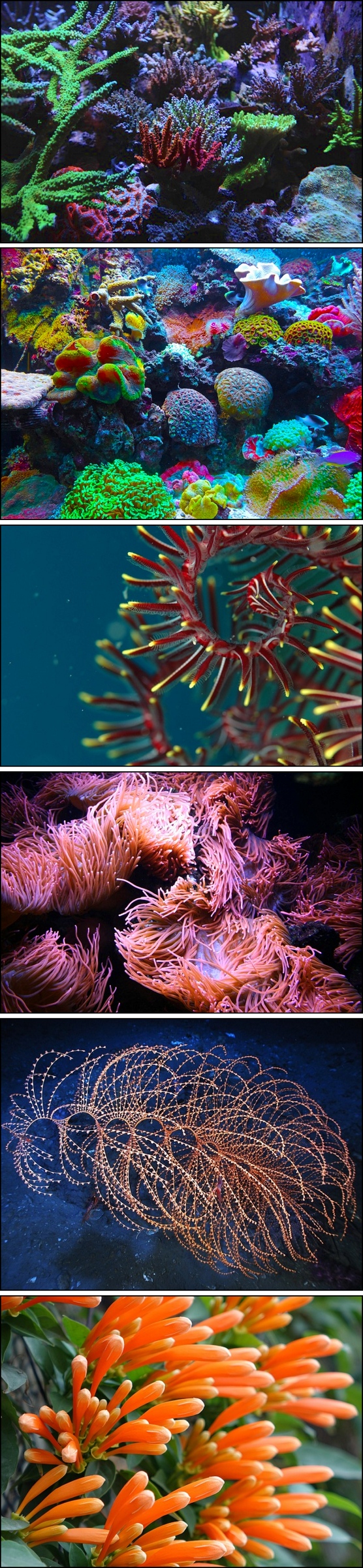
Image #1, reef-tank-3624193.jpg, by agkaimal;
Image #2, coral-567688.jpg, by Jan Mallander;
Image #3, coral-560552.jpg, by toshiyuki tajima;
Image #4, underwater-3171445.jpg, by LO-DESIGN;
Image #5, iridigorgia-79929.jpg – no photo credit provided;
Image #6, firecracker-flower-1885699.jpg, I suspect, is not an underwater plant at all – but it looks so much like many of the (copyrighted) images OF underwater plants that I saw in assembling this montage that I had to choose it. Image by juemi.
All images from Pixabay, some contrast, color, and saturation tweaks by Mike.
Now, picture it out in the open air where anyone can see it.
Finally, picture it made of died glass. Faceted cglass, at that.
Now you’re imagining what the Fields of Glass Coral look like.

Shadow Of Splinter
As I said earlier, Splinter is not where it is shown on the map. But if you walk South from the town, you find yourself entering the Fields of Glass Coral on its northern side – and if you head North from the town, you find yourself entering the Forests of Asthar. Of course, if you walk West alongside the Everflow, you reach a cliff overlooking the Shadowfen, which lies to the East of the Ironbarb Crags, and if you head East, you reach the Farms of Gardenia – which are on the far side of the Glassdust Desert, some distance West of here.
Nobody understands this, but they shrug their shoulders and accept it. So that they can converse about it rationally, some have labeled the apparent position of Splinter as it’s “Shadow” and posited that walking into the Shadow takes you from where the physical reality is to where the Shadow lies.
Others just treat it as an objective reality that doesn’t have to make sense.
Mekkaresh
Mekkaresh is a city, trading post, and holy site to the Lizardfolk who reside in the Southern Crags. They dislike Humans, tolerate Elves, and hate Dwarves and Orcs. They worship Dragons, and consider Dromedyn to be a delicacy. Most people think that they once resided in the Shadowfen but migrated here long ago. Largely tribal in nature, different tribes congregate here at random times for worship and trade.
Each tribe has its own totem, a particular Dragon to whom they bind themselves spiritually, and a tribe’s social standing reflects that Dragon’s current place within the Hierarchy of Dragon-kind. The current attitude and mind-set of that Dragon, a function of its color (according to Lizardfolk beliefs), informs the attitudes, ambitions, personalities, and internal politics of the tribe – sometimes venal (silver), sometimes arrogant (blue), sometimes greedy (red), sometimes angry, aggressive, and prone to violence (black), sometimes shy and withdrawn (brown), sometimes defensive (brass), sometimes protective of others (bronze), and sometimes noble and with a view to benefit all Tribes (gold).
From natural deposits that they have found – and they do not share where – the Lizardfolk acquire various gemstones and trade them for food, clothing, and other items, both necessary and luxury. The price charged depends on the race with whom they are bartering and the general attitude of the tribe.
No tribe has yet been encountered that looks to a Green Dragon, but it is surmised that these are the most religious, the most spiritual, the most artistic, and the most scholarly – and that they spend all their time seeking a deeper appreciation of the natural wonders around them. But that’s all guesswork.
The Lava Uprisings
In the heart of the Southern Crags lie the Lava Uprisings. This is an area where the crust between crags is especially thin and prone to break open, since the lava beneath is under pressure because of the great heat, it breaks out through these openings and erupts into a geyser of lava – until the next rainfall, which cools it enough that the eruption cools and desists, at least for a time.
The region’s reputation is, actually, somewhat exaggerated. In reality, most of the time, a little lava oozes to the surface and traverses ten or twenty feet before congealing. That’s because pressure makes it ooze to the surface, but expansion once it’s up there induces cooling. But every now and then, when the mood takes whoever’s in charge down there, the uprisings come to life and lava geysers erupt like flowers on a spring hillside – for a little while.
Zasleen
Zasleen is a ‘city’ of tents and grass huts thought to be somewhere in the Greater Wastes, occupied by Orcs. It’s the closest thing they have to a Capital, in the eyes of the Civilized races of Topologia.
The reality is a bit more complicated – “Zasleen” is an Orcish ‘state of mind’ more than anything else, meaning ‘minded to gather or moot’. “Traveling to Zasleen” and “Coming from Zasleen” thus acquire slightly different meanings to their superficial interpretations, and – technically – Zasleen can be anywhere an Orc Tribe wants it to be.
But it’s hard to reach Zasleen as a solo act – it generally takes two like-minded groups to tango.
There is also another interpretation of Zasleen – to an Orc, it can mean “of a mind to raid” since stealing something owned by another is considered the same thing as trading for it – it’s just a better bargain that way (from the Orcish perspective). Because the Elves of Asthar are fairly strongly emplaced and protected, it takes more than one tribe to successfully raid into the forests – so Zasleen is also a prelude to doing so. This explains the relationship between the two meanings and shows how the one mind-set can be common to both.
Possession is 11/10ths of the Law to an Orc.
There is a surprising amount of food available to anyone with the constitution and sensibilities (or lack thereof) of an Orc, so they raid Asthar for what they consider luxuries like deer and timber, and across the Everflow for decorative items. Sometimes a tribe will make the difficult journey through the Lesser Wastes and Central Crags along the Optica River, passing through a narrow gap separating the Directionless Void and Mount Optica to raid the Dwarves for Gold and Silver with which to make their decorative Jewelry.
Mount Redtop
The largest mountain in the Crags, it is now thought to be a long-dormant volcano because that best explains the Greater and Lesser wastes. Some think that this is where the Gemstones traded by the Lizardfolk actually come from, but this is nothing more than speculation.
What is not speculation is that the mountain gets its name from reddish mineral deposits at it’s crown. The mountain – and the entire Crags in general – are far too hot for snow to ever fall here, even at great altitude, so this crown of fiery red is visible all year round (unless hidden by storm-clouds).
Mount Optica and the Rainbow Falls
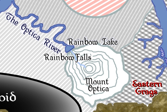
South of The Lava Uprisings lies Mount Optica. This is the volcano that most looks like a stereotypical volcano, at least from ground level. Mostly, it erupted from it’s eastern side, but the last time it became active – and it was quite a while back – it blew a massive crack in the crater rim to the northwest instead. The volcano then became quiescent, and the crater slowly filled with rain to become Lake Optica – not that it’s ever really referred to by that or any other name. That’s because the rainwater trickles out that crack, dispersing into a fine mist as it plunges through a series of cascading waterfalls almost 600m (2000 feet). Along the way, it generates a series of rainbows, one for each descent of the cascade.
When it’s been dry for a while, these can be a little hard to see, but after a few days of rain, different drainage channels in what remains of the volcanic rim on that side are reached by the rising waters and the trickle becomes a roar. Every day of rain generates 2-4 days of spectacular waterfall rainbows before the again slowing to a trickle.
Since some seasons generate more rainy weather events than others, this is at its best (in terms of viewing) exactly when the surrounding areas are at their most inhospitable.
Rainbow Lake and the Optica River
When the waterfall cascades to the ground, it reaches a hollow that has been eroded by the water, forming another lake. This lake is either water-filled or mostly dry (depending on recent weather) but either way, it splashes, and creates one more incredible rainbow, so close to the ground that it feels like you can reach out and touch it.
You can’t, though many have been sufficiently captivated to try without thinking.
Rainbow lake then drains to the Everflow along the Optica River – which, most times, is little more than a small creek. It’s actually pretty unremarkable – and that in itself is unusual in this area.
Environmental Conditions in the Ironbarb
Some of these are broad and general, while others are localized to a specific location because of the nature of the location. Some of the latter have already been described, without much to add, but I’m going to list them all even if there’s no additional text to add to them.
But we start with something broader about which there’s a lot to discuss, the climate.
Climate
The Ironbarb Crags experience four distinct seasons – two wet ones and two dryer ones. Dominant weather patterns change from one to another, largely because of the impact of winds.
Four Seasons
The four seasons aren’t named because while each is distinguished by trends, there’s enough variability in the environment that any given day can be completely outside the trends. While 45°C (113°F) days are unusual in the fourth month, and rain of some sort can be expected almost two days in three (or so it seems), random chance and the geothermal heating of the air can elevate the temperature over 50°C (122°F), and if there is an unseasonal Eastwind, the desert air can add another 8°C (14°F) to that – or take 8° (14°) off it (which is not an improvement, for reasons that will become obvious!)
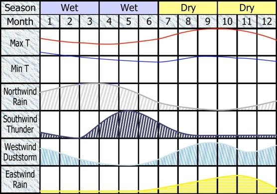
These charts show the ‘typical weather’ that trends in each of the seasons and months of the year. I’ll discuss everything in more detail as we proceed, but I’ll be referring back to this constantly.
Wet Seasons
My original draft had the dry, hot seasons in the middle of the year, bracketed by the two wet seasons, but many of the patterns that I identified were not clear in that formulation; in particular, much of what happens in what was shown as the first wet season (and is now shown as the second) was predicated on what happened in the second (which is now shown as the first).
There may be some temptation to try to map these seasons against the traditional four of Summer, Autumn, Winter, and Spring. Resist this temptation, it will lead you astray. For one thing, such a methodology would have ‘winter’ starting halfway through Month 2 and persisting through to half-way through Month 5. ‘Spring’ would be 1 1/2 months of the second wet season and 1 1/2 months of the first dry season, and so on.
It just doesn’t work well and can be highly confusing.
So the year kicks off with the first Wet Season. (Another point: this ‘year’ bears no resemblance to that used by the Civilized Races.) In this season, Northwinds and Eastwinds dominate, with the first of these increasing in potency and the second declining. The most interesting aspect of this month is the incidence of Southwinds, i.e. Winds to the South. These start low and dip to virtually zero by the end of month 2 only to rise sharply in month 3, setting up an increasing dominance in the second rainy season.
Each of these winds carries different climatic phenomena. “Which way is the wind blowing?” can be a life-or-death issue in the Crags!
Three months after the first rainy season began, the climate transitions to the second. Northwind rains initially dominate, but fall off in intensity and frequency through the season, while Southwinds rise in intensity (but not in frequency), peaking throughout month 5, before beginning to taper off.
The wet seasons have the coldest maximum temperatures, but take a close look at the Minimum temperatures – these start out off the chart! The nights at the start of the first wet season are hot, hot, hot! These fall progressively throughout both seasons, even while the maximums are beginning to rise, presaging the beginning of the dry seasons. The end of the wet season marks the point at which the typical minimum temperature begins to rise once again. Finally, note that there’s a discontinuity in the minimum temperatures experienced at the end of the dry seasons and the start of the wet seasons – the first of those hot-hot-hot nights is taken as a signal by the inhabitants that the season has turned, or is about to turn. It’s one of the clearest signals in the climate!
Dry Seasons
The term ‘dry season’ is a little misleading, though in relative terms, it’s accurate.
Throughout the first of these seasons, there is a rising frequency of Eastwinds, though these tend to be relatively mild until month 9, when they also begin increasing in intensity. Incidents of Northwinds start as infrequent and become even more-so by the season’s end, reaching virtually zero. Southwinds continue to taper off in the first half of the season and plateau at a frequency barely higher than zero – a frequency they sustain through both dry seasons once it is achieved. Rising to dominance over the climate throughout the season are the Westwinds; these start fairly low in frequency and intensity and grow more extreme throughout the first dry season.
The second ‘dry’ season is markedly different. The frequency of Westwinds declines through to the middle of the season, though the intensity continues to increase, reaching a peak near the end of Month 11. It then begins rapidly reducing in intensity even while the frequency is again increasing. The second dry season is dominated by the Eastwinds, which reach a peak in both frequency and intensity at the end of Month 10. Southwinds persist throughout at their low-but-not-unheard-of plateau, and there is a slow rise in the presence of Northwinds throughout.
The end of the first dry season and start of the second sees a peak in the ‘usual’ maximum temperatures, while minimums rise to equal but not exceed their highest levels outside of the beginning-of-year discontinuity. Throughout the second season, these are again slowly declining.
It should probably be mentioned before I dig into the significance of these winds that the areas in the direction nominated by the name of the wind are the areas most strongly affected by them in north-south terms, while the opposite is true of East/West winds. So if there is a Southwind, it will be experienced most strongly in the southern half of the map and less severely in the North, and so on. That matters a great deal and is partially responsible for the differences observed in the different regions of the Crags.
Northwinds
When the wind blows to the north, it flows over the forests (but not the town of Splinter, it should be noted) and eventually reaches the mountains, which thrust it upwards. While quite warm from the heat of the crags at first, it rapidly cools, becoming clouds, which bank up over the mountains and slowly spread south, The rain that they carry tends to be light and intermittent. In central areas, it can be somewhat acidic, but nothing like what occurs at other times. Of greater significance is the cloud cover, which reduces temperatures by day by 4-6°C (7-11°F). If the cloud cover cools the day, it will also cool the night; but if the cloud reaches an area at or after sunset, it will have no effect on the daytime temperatures, and will trap what heat is there at night, turning the decrease into an increase.
A hot night in Northwind conditions also gives temperatures the next day a ‘kick-start’ and are enough to cause a measurable increase in geothermal activity, especially in the north. A cool day or night, in contrast, is enough to diminish geothermal activity, making the Crags about as safe as they get.
There is a slim chance that Northwind rain at its most extreme – the end of the first wet season and beginning of the second – will be heavy enough to cause flash-flooding in the northern parts of the Crags, revitalizing and growing the mud flats (normal rainfall levels are only enough to sustain them).
Southwinds
The southern edge of the Crags abuts directly the mountains, and that’s enough for a Southwind to melt / evaporate snow in the wet months on those peaks. This can cause serious flash-flooding in the southern third of the map, declining as one continues north – but even ‘moderate’ flash flooding is something to be concerned about in the Crags!
But the now-moist air gets pushed high up into the atmosphere where it forms storm-clouds, producing thunder and lightning – and sometimes (not always) intense rain for short periods. These storms tend to be fast-moving at first, slowing as they reach the central areas, only to speed up again as they traverse the north and the Forests.
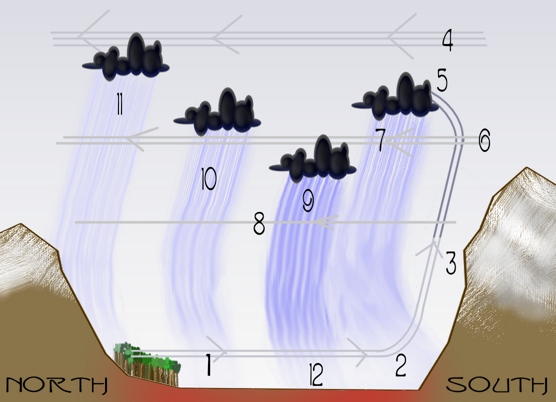
I’ve put this diagram together fairly quickly to explain what’s happening. See below for the key that goes with it.
1. Medium winds to the south carry slightly-moist air over geothermally-heated ground.
2. Blocked my mountains, and already rising, they get pushed up.
3. Passing snow, they capture more water content.
4. Strong winds in the other direction – because the winds of (1) have to come from somewhere.
5. Storm-clouds result.
6. Cooling and heavy with water, these descend into a region where the winds to the north are not as strong.
7. Rainfall, the clouds zipping by in the medium winds, and continuing to cool.
8. A region of very light winds.
9. The more the clouds cool, and the more they cool the ground below, the lower into the light-winds region the clouds sink. Rain is at it’s heaviest.
10. As moisture leaves the cloud, it lifts, speeding up as it gets driven by the stronger winds.
11. By the time the rainfall gets past the forest, there’s not a lot left, and the clouds are likely already dissipating. But there might be a light snowfall, effectively migrating some snow cover from the mountains to the south to those in the north.
12. The ground is still hot. A lot of the rain will evaporate before striking it, siphoning off additional heat, becoming water vapor, and getting driven by (1) back to repeat the cycle.
Storms, by their nature, tend to be more intense but short-lived phenomena. They also tend to occur in middle or late afternoon. As a result, storms generally invoke the ‘late arrival trapping heat’ pattern – but they also do cool the ground significantly, and a good thing, too – humidity is often much higher afterwards, and the combination of high heat and humidity is a proven killer.
Westwinds
Westwinds carry lots of moisture from the Shadowfen from the East to the West. The major unusual characteristic of these winds is the dip in months 10 and 11, and that’s because they have often dumped most of their rainfall on the Shadowfen before they even get to the Crags in those months. Well, some of the time at least. The eastern half of the map tends to receive the bulk of what rainfall remains, but there is so much that the entire crags can be blanketed.
The quantities of rain frequently cause flash flooding. This is especially true in the first Dry season. It should be noted that while these are far more intense rain events than those from the other direction, and often persist for several days, they are less frequent at the best of times than the other rain events. But they can blanket the eastern half of the map in cloud cover, with consequences as already described, even if they no longer have any rain to give.
Eastwinds
Most terrifying of all are the Eastwinds. These are already hot and dry from passing over the Desert to the west. When they are light, they only add a few degrees to the temperature, and they tend to push the moisture of the Shadowfen further away, delaying the next Westwind event.
When they are moderate, they can carry sand-storms to the western third of the region, and add up to 8°C to the temperature, as stated earlier.
But, when they are strong, the sand-storms become Flensing – see The Wastes | Forgotten Realms Helps, the section on Sand and Wind is a little more than 1/3 of the way down the page.
“Flensing” is used to mean a scouring, flesh-stripping effect from the wind-driven sand – in effect, sand-blasting flesh away. This also cuts off much of the natural sunlight, causing temperatures to drop – but that’s of little comfort to anyone caught out in the open.
These sandstorms rarely penetrate further than 1/3 of the map to the east, but the further beyond this point they go, the worse they become – there are parts of the Crags that are hot enough to melt the sand in the air when they are ‘excited’ by the arid winds. Essentially, a horizontal rain of molten glass.
Two areas in particular should be noted – the Dome Of Frozen Fire and the Lava Uprisings. In any sandstorm, the last place you want to be is East of either of these!
Maximum Temperatures
The lowest ‘expected’ maximum temperature occurs at the start of the second wet season, and is typically about 30°C (86°F). The highest is typically at the end of the first dry season and start of the second, and is typically around 45°C (113°F). Cloud/sand cover and rain can affect these, as described earlier. There is also natural variation in the geothermal heating of the ground and hence the air, which can add or subtract another 5°C (10°F) on top of the effects already described.
There is a lot less variation in the maximum temperatures than in most places because much of it derives from Geothermal sources.
Minimum Temperatures
There is rather more variability in the night-time temperatures. Any sort of significant wind can have a significant cooling effect, while cloud cover can trap the heat of the day while increasing the humidity. Nevertheless, the proximity to the surface of geothermal sources of heat means that the climate is poised on a knife-edge and normal temperature variations from climatic events can be amplified as a result.
The lowest minimum comes at the end of the second wet season and can be as low as 20°C – which can be quite chilly when effects such as wind cooling, rain, and altitude are factored in. An early-evening thunderstorm from the South can carry rain at something close to the frigid temperatures of snow, and even though some of this will evaporate before reaching the ground, it can cause up to a 12°C drop in night-time temperatures (22°F).
The highest minimums outside of the start-of-year discontinuity are around 25°C, but cloud cover can add or subtract 8°C to this, and random variation another &plusminus;10°C. So 43°C (109°F) is not out of the question – and geothermal sources that have been excited by a hot day can compound with these effects in some areas as well.
Noxious Fumes
Some days, the wind doesn’t blow much at all, and these can be some of the most uncomfortable, because the air in the Crags is naturally noxious. It’s relatively rare for this to reach dangerous levels, but ‘uncomfortable’ is frequent.
Some areas, especially the Lava Uprisings, release additional fumes from time to time, low clouds of invisible and unbreathable air. If one of these is encountered, the only hope is to hold one’s breath and climb as high as you can as fast as you can, hoping to rise above the level of these gasses.
Acidic Rain
Any rain that has been carried over a significant portion of the Crags has some degree of acidity. The best in this respect are the Southern winds, because they discharge their water content quickly. The worst are the Northern winds unless in the extreme east or west of the map; in the East, it’s the Westwind that’s most prone to this, and in the West, it’s the Eastwind – though the latter generally brings sandstorms, not rain.
Flensing Dust-storms
Already described.
Flash Flooding (acidic waters)
Mentioned but not described – some of the minerals in the ground (a lot of it doesn’t qualify as ‘soil’) and create acidic waters. That’s bad enough when you’re talking a watercourse like the River Vertigo, but when you’re talking a flash flood, it’s a hundred times worse.
Lava Uprisings
Mentioned, not described in detail, but what’s been stated should be enough – geysers of lava! Erupting without warning!! How much more do you really need to know? No matter how short-lived the eruption – and they are typically measured in seconds, a handful of minutes at the most – it’s bad news for it to be right next to you, and worse for it to be upwind.
Hot Mud
At several places in the Crags, the source of geothermal heat is closer to the surface than might be expected, but it’s also a little cooler – enough that surface climatic conditions can tip balances one way or another.
When there is no rain on a hot day, these mud pools can reach temperatures between 70°-90°C (158°-194°F). Exposure to mud at such temperatures causes immediate 3rd degree burns, destroying the skin and some of the layers of tissue beneath, withering the affected body parts. This, of course, is extremely painful, and can cause people to collapse into the mud, increasing the exposure. Skin around the destroyed areas will form large blisters and this skin will also be lost over the course of the next few hours. At the same time, steam from the mud will attack the respiratory system including the mouth, throat, and lungs. These usually swell, and this can be enough to cut off all airflow into the body. Finally, there is a very high risk of infection from the burns.
Over the next few days, secondary effects will occur. System shock will reduce the blood flow to vital organs. Dehydration can occur from fluid loss from the burned regions of the body, which weep continuously. Affected limbs become permanently useless and may need amputation to protect the life of the burn victim.
Even without considering infection, such burns will generally be fatal if over 25% of the body is affected – that’s both legs up to the knees or one leg to the knees and an arm to the elbow. With infection taken into account, this threshold falls to as little as 9-10% – one hand and wrist are enough.
Amputation of damaged limbs and magical healing lift the threshold considerably – up to perhaps 96%. Without amputation, 70-80% would still be possible, though there would be considerable permanent scarring and the limbs would still be somewhere between weak and completely unusable. Fortunately, a Reset will eventually put things right!
Rainy days not only block the heat from the sun, they bring cooling rain. That this is a necessity for replenishing the liquid in the mud pools doesn’t diminish the impact on the temperatures. On such days, the temperature of the mud can fall to as little as 40°C (104°F), though this lower limit would only be reached on extreme days with Southwind thunderstorms. On the very coolest days, the mud is almost cool enough for bathing – though this is not something to be risked casually!
And yet, the mud pools are central to one of the most complex ecosystems imaginable, a three-way – some would say four-way – symbiosis. I’ll get into that in the “Plant Life” section, below. But one of the byproducts of this are the Crystal Towers described earlier.
Reflections Of Deception
You’re in a maze of mirrors, in which every surface is curved in extreme and unnatural ways. If the sun is not directly overhead, it reflects off these surfaces so that there might appear to be five – or twenty-five – suns, all in different directions. It’s impossible to discern east from west, north from south. The lack of straight lines confuses the eye, and forces continual twisting and turning this way and that – so no sense of direction can be trusted, either.
Adding to all of this can be extreme heat haze and a sort of ‘hot fog’ that results from rain evaporating at high temperatures, up to 120°C in the worst places, where the steam becomes superheated.
For the more technologically-literate, iron deposits within the columns make compasses useless – they simply point toward the nearest large pile of rock.
Worst of all, when a flensing sandstorm reaches this far into the interior, it gets compressed into the narrow passages, often only half a meter wide (1.5 feet), doubling or tripling the already-deadly event.
Things get even worse at night, when what meager light is naturally available gets refracted and reflected into nothingness, dissipated and dispersed. Even torchlight and magical light sources only illuminate a few feet around you, 5′ maximum.
Thankfully, there’s only one place in the Crags where these conditions obtain, though it’s a significantly large one – the Directionless Void.
Heat-haze & Mirages
Even outside the Void, there are parts of the Crags where heat haze and mirages are a significant problem, because they aren’t just the result of natural environmental heat but also heat from geothermal sources. This means that they can be a lot stronger, and a lot closer to the viewer, than most people would ever expect. On the hottest days, effective visibility can be reduced to as little as 50m (165′). That’s a problem when there are hostile life-forms around – who may not be subject to the same limitations you are.
Dragons and Lizardfolk, in particular, seem more tolerant of this effect than Humans, Dwarves, and Dromedyn. Elves seem to be even more susceptible, their normally-keen sight betraying them.
Orcs and other species with enhanced olfactory capabilities also suffer less from this problem, being able to supplement their sight with a second sense. However, any sort of tremorsense is largely worthless for it’s usual purposes in this environment, there is too much geothermal activity producing false impressions. Such senses are far from worthless, however; they can provide a vital few extra minutes or seconds of warning before a geologic event.
This isn’t the only danger posed in the Crags from this source, however. Thermal stratification of the air can arise when there are light breezes and broken cloud conditions, and these can cause horizontal mirages, either above the perceiver or below their eye-line. This is a fairly rare phenomenon but it can be deadly when you’re trying to skirt mud-pools and can no longer see the ground beneath your feet, just a blurring, shimmering, dancing shadow.
Seismic events and Volcanic Eruptions
These are rare; many of the surface phenomena of the Crags dissipate tensions that might otherwise build to pose a more extreme danger. Nevertheless, they have happened in the past, and so can happen again – without a whole lot of warning.
The hotter the day, the more likely these events become, but the pressures that cause them are also more likely to be vented away on such days. A hot day after a sustained period of relatively cold weather is when these pose the greatest risk of occurring. Early-to-mid-morning are the times of greatest hazard on any given day.
….and that takes me to about half-way through this subject. That’s right, I think there will be as much again still to come on the Ironbarb Crags – I really was on creative fire while working on it! But most of the above was already written by the time I decided to delay it and threw together last week’s ‘best of 2016, part 1’ – so I’ll get next week’s part 2 of this post done in the time I would normally spend writing a new CM post, and then have two weeks up my sleeve to focus on Trade In Fantasy Chapter 5 Part 5 – I’ve already done 552 words of that, outlining the content to follow as it’s intended to be, and it’s already clear that it’s going to be another big one – and that’s even if I don’t strike problems the way I did with the fortifications section!
But I’ve also got parts 2 and 3 of “the best of 2016” up my sleeve as fill-ins if I need even more time, so I’ll take as long as I have to in order to get it right.
Last-minute Update:
Splitting this post in two meant that I needed a new feature image to go with the second part. I knew exactly what I wanted to depict, and exactly how to do it, so I allowed a day for this. So far, it involves more than 1000 layers of composite, has taken a day-and-a-half more than scheduled, and still isn’t finished. At the current rate of progress, one more day’s effort, and a bit, should see it done. So, in the end, I’m not sure that I’ve actually gained any time by doing so. But the end result will be worth the effort, yielding a much better article.

Discover more from Campaign Mastery
Subscribe to get the latest posts sent to your email.


September 9th, 2025 at 2:19 pm
[…] just wanted to reassure readers that the post, Topologia: A Strange Campaign Setting, Part 4a is NOT spam and is safe to […]
September 18th, 2025 at 4:29 pm
*Topologia: A Strange Campaign Setting, Part 4a* sounds fascinating! I love how the article dives into unique world-building elements and unconventional campaign ideas—it really sparks creativity for tabletop RPG enthusiasts. Personally, I enjoy settings that challenge traditional norms and encourage players to think outside the box. It actually reminds me of Photocall TV, where exploring lesser-known channels and content can lead to unexpectedly exciting discoveries. Which part of this campaign setting do you think would be the most fun or challenging to play?
photocalltvvgh recently posted..Photocall TV APK [Descarga Gratuita para Android y iPhone]
September 19th, 2025 at 3:29 am
I came within an inch of discarding this comment as spam because of the blatant self-promotion in the second-last sentence which the link then doubles down on. But then I realized that maybe my post really does remind you of your own workplace in this respect, and it was potentially a legitimate comment, however suspicious it seemed at first glance.
To answer the question with which you conclude, each environment in Topologia is designed to present different challenges and roleplaying opportunities. Depending on your preferred style of play, any one of them could be considered the most challenging or the most fun. But the intended correct answer is the mystery of Topologia itself, and exactly what is going on? The GM knows, because the answer was given outright in the first post of the series, but to a player who has to figure it out based on the in-game events and then work out how to use the unique nature of the place to their benefit, that is probably the greatest challenge. And if you’re the type of player who enjoys solving puzzles and answering mysteries, it would also hopefully be the most fun. If not, the setting is designed to present highly serialized threat-of-the-week challenges with the equivalent of a video-game’s saved-game mechanism built in – but the PCs are the only ones who can even notice it. Think of Edge Of Tomorrow but without anyone who knows the answers there to provide explanations, and while the game resets, it then proceeds along a different path instead of constantly repeating the same day.