The Power Of Basic Utilities

Today I’m going to tell readers about something I’ve been working on a lot over the last few months, because it highlights an important principle – you can usually do a lot more with basic tools and utilities than you think.
A Recurring Pattern
Every now and then we seem to get waves of tools and utilities emerging, as though in support of the premise, “One Task, One Tool for that Task”. It happens in real life, it happens in the world of computer software, and it happens in RPGs.
What usually happens is that someone decides that they need to perform a particular task and either none of their existing tools and utilities will do the job, or none of them will do it in the way that the person wants the job done. So they write a Utility to do that job for them, and then make it available to others.
Eventually, that functionality gets incorporated into a larger application, and the Utility gets abandoned and fades away – if the incorporation is successful. Sometimes, the developer of the larger application can’t do the work cost-effectively or without hitting legal trouble, and they will buy the rights to the Utility from the original developer – creating an incentive for that developer (and others like them) to go write another one.
I wrote about the Office Suite that I use in The Braiding Of Plot Threads, more-or-less in passing. For some reason, it’s not a subject that I’ve written about = maybe because what I use might not help others, or because I have a fairly eclectic selection that’s built up over the years.
I might have to do something to correct that deficit in the near future…
RPG Equivalent
The RPG equivalent is writing a standalone mini-supplement to solve a particular creative need, and offering it either as a free download from somewhere or through someplace like RPGNow. These succeed because they plug a hole in one or more game systems. When a new version of those game systems gets written, the best of these solutions get incorporated into the revised mechanics, or the authors put in place an ‘official fix’ for the hole – either way, the standalone product goes away.
The reality is that people often already have all the tools that they need, they just don’t want to – or have time to – do the work, or they don’t know exactly what their existing tools can do.
The back-story
The players in my superhero campaign have chosen, as their new base of operations, a Mansion in Royal, Arkansas. The process of making this their Home-away-from-home and a functional base of operations is now underway.
Meanwhile, I have been working on implementing their decision into the campaign in various ways, effectively converting the reality of Arkansas as it now is (because that’s what the internet gives me access to) into the fictional post-Ragnarok 1986-era version of Arkansas that exists in the campaign.
I want to admit up-front that there is absolutely nothing stopping me from inventing things ad-hoc as needed – except that spur-of-the-moment creativity is rarely as effective as putting a little time and effort into things in advance.
Purposes
One of the things that I wanted to do is create a sortable, searchable, database of businesses and interesting localities within ‘adventuring range’. The latter is defined by the parameters of this phase of the campaign, and can grow and change in time.
Originally, my intent was simply a list of townships, but it quickly grew from that basic concept. If the PCs needed a set of four different banks in their local vicinity, for example – a need that I both anticipated and that has now materialized within the campaign – having a list of the ‘real’ banks in their local area would save me a lot of work. If they find that they need a particular type of consultant, or a particular chemical, or whatever, I wanted to know where they might look for that resource.
And, I wanted a spur to my creativity in coming up with adventures.
Data Acquisition
Before you can create a database, you need the information with which to populate it. Of course, you need a preliminary design so that you know what information to look for, too!
In this case, what I wanted was a list of targets.
Basic Parameters
Operations of the PCs meant that road distance and driving time were all that would be relevant for the most local business operations – Royal and the nearby Hot Springs, basically. Outside of that, I would also need straight-line distances.
Anything and everything within about 100 miles of their base of operations was fair game.
I decided fairly quickly to exclude churches, temples, and the like, because none of the PCs is especially religious and most of the adventures involving such were becoming stale. But businesses and retail operations and landmarks were fair game. Later, I revised those parameters to specifically include graveyards, because I had a specific idea regarding them. I also excluded hotels and wedding venues and the like; the key intention was to list the suppliers that the PCs might want to buy from, and the services that they might want to employ.
Scope
Arkansas is a little like medieval France – some bigger places (but none as big as you would expect) and a huge number of much smaller places. In fact, if you count suburbs as ‘towns’, you can get the sense that the average gap between such is 1 every 10 miles or so. If each location has between 3 and 50 businesses, how many does the zone of interest run to? How big a list are we talking about?
What I’ve essentially defined is a circle 100 miles in radius, with an excluded zone in the middle of 10-16 miles radius, and what I want to know is how many more 10-mile radius circles I can fit into it. Multiplying the answer by 3-to-50 gives some indication of how many entries to expect.

100 miles radius = 100 × 100 × π = roughly 31,416 square miles.
10 miles radius = 10 × 10 × π = roughly 314.2 square miles.
16 miles radius = 16 × 16 × π = roughly 804.3 square miles.
Difference = 30611.7 to 31101.8 square miles.
Divide by 314.2 = 97.4 to 98.987 localities. Call it 100 for convenience.
Multiply that by the estimate of 3-50 data points per locality, and you get 300-5,000 entries.
But this is very sensitive to the initial inputs, especially the gap between localities and the number of entries per locality. If the true gap is, say, 8.5 miles, then I get 30611.7 to 31101.8 divided by 226.98 square miles = 135 to 137 localities. Call it 136. If the number of data points per locality is more like 10-100, that’s 1,360-to-13,600 entries.
Realistically, I expected 1000-2000 entries.
Approach
The basic approach to acquiring those entries was simple: Call up Google maps, locate the position selected for the Mansion, measure out a straight-line distance of 141 miles (a right-angle triangle with sides 100 miles long gives a hypotenuse of 141) at a 45-degree angle to get the corners of a box that’s 200×200 and centered on the zero point. Then start listing localities.
Once I have that list, I can zoom in on each and create a list of the entries of interest.
Map
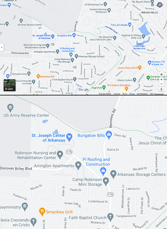
As always, shrinking a full-screen capture down to fit the available visible space at Campaign Mastery remains a challenge, especially if legibility is to be retained. The top part of the image shows the whole window, resized to fit; the bottom is an extract from the source at something close to actual size.
Creating the list is just a matter of being organized and systematic.
List
I ended up with 343 localities, and that’s without treating suburbs independently. That’s very bad news because it means that the average gap is nowhere near 10 miles. Doing the reverse calculation – square root of (31101.8 / 343 / π), I get 5.372 miles between localities.
But that’s okay – if the number of localities is 2-3 times as many as expected, I can simply list only 1/2 to 1/3 of the entries for each location. A little more selectivity and a little more ruthlessness would keep the job to manageable proportions, or so I thought to myself.
Here’s a sample of what the resulting list looks like:
Chappell Armory (Army Reservist Training Center)
Camp Joseph T. Robinson aka Camp Robinson (Army Reservist Military Base)
Arkansas Storage Centers (Self-Storage Facility)
Smackies Grill (Discount Restaurant)
S&V Renovations LLC (Remodeller)
Family Dollar, 5613 MacArthur Dr (Discount Store)
Levy Concrete, 5613 MacArthur Dr, Crystal Hill (Discount Shop)
Dollar General, 6700 MacArthur Dr, Crystal Springs (Discount Shop)
Two Men and A Truck, 4125 Crystal Hill Rd Ste A, Crystal Hill (Removalist)
Smith Campers (Campervan and Caravan Dealer)
Nicky Houses Cleaning (Janitorial Services)
Ed’s Corvette Body Repair (Auto Body Shop)
Hatchet Jacks Sport Shop (Fishing Store)
Taco Mexicano (Fast Food – Mexican)
Skyline Automotive (Car Repairs & Maintenance Service)
Laffert Equipment Manufacturing (Automated Systems Manufacturer)
After each entry, using copy-and-paste, I then added a line for the data to be gathered:
x miles, x min, x km (x miles) straight line
I ended up with about 1200 entries to process. Sounds good, right? Well within estimates.
You may also observe that I added a description of what the business was or did. In a lot of cases, these were obvious; in others, I was greatly assisted by the fact that if you hover your pointer over an entry, a pop-up appears within the map that contains additional information about the place – sometimes an address, sometimes a photo, sometimes a description. I soon came to the conclusion that most of these were provided by the business themselves. I have an illustration of that, but I’ll save it for a few minutes.
Map Scale
I was, in fact, close to completing the task when I had my graveyard brainwave and decided to add them to the list. After all, how many could there be?
If those sound like famous last words…. The reality was that I had to zoom in closer than the 1km-per-inch that I had been using in order to see most of the cemeteries on the map.
And when you do that, you discover that there’s a lot of businesses that simply aren’t shown until you get in close enough. Important businesses, ones that should be included.
Long-story-short: The list of entries now has 2837 items. I keep finding more to add. About 300 of the additions are cemeteries, and about 1500 are places that I overlooked on my initial sweep, by using too small a scale. Ultimately, I went to a scale of about 200 ft per inch outside of urban areas, and 100 ft per inch within urban areas. This still won’t show everything – most shopping centers are represented by only one or two entries out of maybe 50 stores – but it’s good enough.
Data Processing
But that lay awaiting discover in my future as work got underway.
Basic Tools
I want to make it clear how basic the tools were – pencil and paper to start with, then a text editor (the same one that I use to write adventures and Campaign Mastery articles), and my web browser.
Windows Arrangement

The screen capture above shows the basic layout that I employed: text editor on one side, at a fairly narrow width, and browser window with map and navigation panel on the other. I had no control over how much screen real estate Google Maps used for it’s navigation panel (visible on the left-hand-side of the browser), I needed a reasonable amount of space for the map itself, and whatever was left was used by the text editor.
I quickly discovered that if I chose a text-editor-window that left the last “x” – the one in (x miles straight line) – at the end of a line, I could simply use the “end” key to get there, and repetition made even the smallest time saving worth the effort.
I had three additional factors to contemplate as I went.
Correcting for 1986
Back in ’86, there were nowhere near as many foreign-car dealerships. There were a few, but nothing like there are now. There were genetic testing labs, and medical imaging was far more primitive – and less common. Instead, we had video rentals, and record stores, and so on. Every time I found a business that looked like it didn’t fit the 1986 era, I would replace it with something era-appropriate that wasn’t around in modern times. Even so, stores like Blockbuster are probably under-represented.
Correcting for Campaign
I also had a few business operations that never existed in real life but that either had been, or should be, established within the campaign. Entirely fictitious creations, but I actively looked for ways to insert the Campaign Continuity into the database.
I added things like a Kzin spaceport / launch & landing facility, for example, and thought about crew needs and human proclivities – that’s why one fast food joint of a type that seemed over-represented became “Cardinal Landing”, offering Americanized Kzin cuisine for the curious and the real thing for the benefit of the crews, and a real pet grooming establishment became “Kitty Pride Fur & Grooming”, a Kzin Grooming and Clan-marking establishment, and a generic gift store became “Kzin Imports” – no prizes for guessing what they sell, both wholesale and retail!
Rebuilding after Ragnarok would have created considerably more builders, electricians, plumbers, etc, so I deliberately over-represented them on my list. But most of these would now be starting to struggle – most of the rebuilding has now been done, and the world is starting to return to whatever passes for “normal” in a world in which Ragnarok happens – and is stopped by superheros.
Sparks Of Inspiration
The third and final factor to be taken into account are outright inspirations. A business that didn’t exist in the fictional 1986 could become something far stranger – sometimes with a name change, sometimes not – simply because it offered opportunities for adventures. A “Geo-chemical & Genetics Research Lab,” for example. An “Exotic Meat Butchery”. A “Genetic Engineering Company”. And so on.
For example, when I went to screen-capture one of Google Maps’ popup descriptions – I wanted one that was as complete as possible – I came across this:

“Omega Technical Violator Center”, described as a Prison. It’s NOT on my list of entries (yet).
I can well imaging that in real life this is a location for low-risk short-term prisoners (unpaid parking tickets, anyone?) – I didn’t bother to look it up. Because the name itself, and the descriptor as a “Prison” is suggestive of something completely different, in a superhero world. This is now a high-tech super-max prison for supervillains, a very different interpretation of the term “Technical”!
Doing The Research
So I took the whole-of-screen capture presented earlier and added some graphics to highlight the process of completing the data capture.
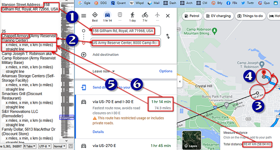
Don’t worry, I’ll be zooming in and going into specifics – this is just to give you an idea of the overall workflow, showing it to be a six-step process.
I’ve divided the work up into full-page blocks that take between 60 and 90 minutes to complete. If you look closely at the Text Editor, just after the blank space, you might just be able to make out a “25” – that tells me that I have 25 full-screen lists to go.
And if you look at the Greeked-text whole-of-document panel on the right-hand-side of the editor, you can get a sense of just how big that 25 pages is, compares to the work already done (perhaps that should be, “how much has already been done, compared to that 25 pages”).

Acquisition, Step 1
Step one only has to be done at the start of a session.

I highlight the address of the mansion in the text editor, copy it, and paste it into the Map Search.
Acquisition, Step 2
![]()
For the first item, I then add ” to ” and then the name of the business to be located to the search. Google maps will then present me with one or more alternative interpretations; I pick the right one.
The search box splits into two, one for the start point and one for the chosen destination, both already filled in for you.
On subsequent searches, the two separate search panels already exist, so I just have to click in the box and over-type what’s there with the next name.
Sometimes, you have to specify the street number and name (if they are known) or the locality (if known) in order to find the business. I didn’t know that at first, but once I discovered the fact, I started noting the (incomplete) address when I could get it from the hover-over described above – that’s why some of the unprocessed entries already have the location listed.
Acquisition, Step 3
Google also (usually) adds the address, which I then type after the name in the text editor.
Google is not always very good at getting the locality right – it defaults to the nearest big settlement, not the actual location. The same is true of suburbs of larger cities. I list the locality both ways, putting the real locality in brackets after the “map search” answer.
Acquisition, Step 4
To measure the straight-line distance for the first time, you have to right-click on the start location, and then somewhere near the end location. I zoom in to the 50′ scale (which is probably more accuracy than needed) in order to do so, then zoom back out to place the destination marker.
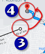
Zooming in to the destination point indicated by Google’s trip calculator, I can then click-and-drag the straight line destination marker to that it coincides – moving (3) to (4) on the captured image above.
Thereafter, when you change the destination (in Step 2), the straight-line-destination marker stays where it is, and it has to be shifted again, while the start-position marker remains unchanged. So this part of the process gets quicker for subsequent searches.
Acquisition, Step 5
![]()
From the information panel on the left of the map, I locate the distance and travel time, and enter these as the first two ’empty’ x items on the blank in the text editor.
That sometimes entails changing the route offered by Google, it doesn’t always make the best choice.
It also requires converting the hours-and-minutes time that often results into just minutes by adding 60 or 120 or whatever.
Acquisition, Step 6
The last step is to look at the “measure distance” box at the bottom of the map and extract the Total distance.
Because I’m in Australia, where km are the default, the distance is shown in km with the miles in brackets afterwards; I would presume that if I lived in the US, it would only show miles, or it might show miles and put kilometers in brackets afterwards.
![]()
This is shown to far greater precision than I need; I round off to the nearest 0.5 km / 0.5 miles. This means that I can get a little quick and sloppy in position the start and end points of the straight-line measuring tool, greater speeding up the whole process.
Why do I need the straight line distance at all?
The PCs are going to get to “superhero emergencies” by flying.
Flight speed in the hero system is given in inches per second, and there are 2m in every Hero-inch. And, of course, you fly in a straight line, instead of following the sometimes convoluted road routes.
Strictly speaking, I don’t need the distance in miles at all – but it will provide a convenient reliability check on the quality of data once it gets entered into the database.
Problems & Solutions
Google Maps is sometimes very broad in its interpretations of the name you’ve searched for, but there are times when the slightest error in punctuation or capitalization means that your search won’t be found.
So I’ve taken extra care to match what I’ve listed in the text editor to the exact spelling shown on the map. But minuscule errors, like leaving (or adding) a full stop after “Inc” or a comma between business name and “LLC” can make all the difference in the world.
Sometimes, though, all of the above is not enough. When that happens, I’ll try a sensible best-guess for the locality, on the presumption that I’m more likely to list two things that are close to each other, sequentially. That’s best-guess #1.
Best Guess #2 is the actual locality of the previous destination, (because Google is inconsistent). Best Guess #3 is always Hot Springs because I went over the local area with a finer comb. Best Guess #4 is Little Rock because it’s biggest.
If that doesn’t work, I’ll cautiously try some obvious variations on the spelling, as described above.
If I’m still coming up dry, it’s time for desperate measures. Option #1 is to get rid of the measure distance box and clear the destination field; doing that lets me click on a business name on the map and Google will decide that’s where I want to go, and fill in the destination search box appropriately. But for that to work, I need to find it on the map, and that’s sometimes easier said and done. I won’t spend too much time searching, because….
Google maps is incredibly efficient at removing businesses if they go out of business, or at processing changes of name. And a gap of one-to-eight weeks between my listing it as an entry to search is more than enough for this to happen. So my last resort is to open a new tab with a regular Google search, because other sites – like Facebook – are slower to take down old information. Once I have the street address, I can enter that into the search panel, ignoring the business name, and the problem is solved.
My absolute last resort is to treat the location as “lost” – set it aside and just keep an eye open for it as I continue on.
It’s near-certain that any given page will have at least one or two cases where I have to resort to ‘stronger measures’ than the quick-and-easy Google Maps search. These techniques are in the sequence presented because I’ve found which ones are the least work for the maximum likelihood of getting a result.
End-Of-Page
Google Maps appears to chew up a huge amount of disk cache. By the time I’ve done about a page-and-a-half, Chrome will start throwing up “Not Responding” messages that will grow progressively worse; by the time I’ve done two pages, the browser is essentially frozen.
The only solution to this problem (aside from more memory) is to close the browser and then start again. So that’s exactly what I do. But first – just in case something goes wrong – I’ll save the updated text file!
And before I do that, I’ll cut and paste the page that’s been done to the end of the list of completed work, so that the line with the mansion address is near the head of the next page to be processed.
The List After
After about an hour’s work, I’ll have a page of completed results. For the sake of being complete, here’s the most recently-completed set of results.
Burger King, 4227 Camp Robinson Rd, North Little Rock (Crystal Hill) (Fast Food)
71.9 miles, 69 min, 94 km (58 miles) straight line
Senor Tequila (Bowman), #A1, 1011 S Bowman Road, Little Rock (Brodie Creek) (Restaurant & Bar – Mexican)
63.5 miles, 63 min, 80.5 km (50 miles) straight line
Senor Tequila, 2000 S University Ave, Little Rock (Boyle Park) (Restaurant & Bar – Mexican)
66.5 miles, 64 min, 85.5 km (53 miles) straight line
Senor Tequila (Cantrell), 14524 Cantrell Rd, Little Rock (Woodland Heights) (Restaurant & Bar – Mexican)
68.7 miles, 67 min, 80.5 km (50 miles) straight line
Senor Tequila (Sherwood), 8605 AR-107, Sherwood (Apple Valley) (Restaurant & Bar – Mexican)
74.7 miles, 75 min, 99 km (61.5 miles) straight line
Senor Tequila (Maumelle), 9847 Maumelle Blvd, North Little Rock (Maumelle) (Restaurant & Bar – Mexican)
69.7 miles, 66 min, 86.5 km (54 miles) straight line
Senor Tequila, 4304 Camp Robinson Rd, North Little Rock (Park Hill Historic District) (Restaurant & Bar – Mexican)
71.8 miles, 69 min, 94 km (58.5 miles) straight line
McDonalds, 4422 Camp Robinson Rd, North Little Rock (Park Hill Historical District) (Fast Food)
72.0 miles, 69 min, 94 km (58.5 miles) straight line
Popeye’s Louisiana Kitchen, 4704 Camp Robinson Rd, North Little Rock (Park Hill Historical District) (Restaurant – Chicken / Cajun)
72.0 miles, 70 min, 94 km (58.5 miles) straight line
Kroger, 4401 Camp Robinson Rd, North Little Rock (Park Hill Historic District) (Grocery Store)
72.0 miles, 70 min, 94 km (58.5 miles) straight line
Edwards Cash Saver, 3801 Camp Robinson Rd, North Little Rock (Park Hill Historic District) (Grocery Store)
72.1 miles, 69 min, 93.5 km (58 miles) straight line
El Paisano, 406 W 47th St, North Little Rock (Grocery Store)
72.2 miles, 69 min, 94 km (58.5 miles) straight line
Arvest Bank, 4724 Camp Robinson Rd, North Little Rock (Park Hill Historic District) (Bank)
72.3 miles, 70 min, 94.5 km (58.5 miles) straight line
Hogg’s Meat Market, 3901 John F. Kennedy Blvd, North Little Rock (Lakewood) (Butcher Shop)
71.1 miles, 68 min, 94.5 km (59 miles) straight line
Bargain Brothers NLR, 4135 John F. Kennedy Blvd, North Little Rock (Lakewood) (Discount Store)
71.4 miles, 69 min, 94.5 km (59 miles) straight line
Hobby Lobby, 4701 John F. Kennedy Blvd, North Little Rock (Lakewood) (Craft Store)
71.8 miles, 69 min, 95.5 km (59 miles) straight line
Camp Robinson Mountain Biking, North Little Rock (Crystal Hill) (Sports Venue)
76.7 miles, 78 min, 92.5 km (57.5 miles) straight line
Pi Roofing and Construction, 6109 Remount Rd, North Little Rock (Indian Hills) (Roofing Contractor)
73.2 miles, 71 min, 95 km (59 miles) straight line
Bungalow Bills, 22 Remount Rd, North Little Rock (Indian Hills) (Novelty Store)
73.5 miles, 72 min, 95 km (59 miles) straight line
B.E.E. Promotional Products, 7000 Remount Rd, North Little Rock (Indian Hills) (Gimmick Manufacturer)
73.8 miles, 72 min, 95.5 km (59.3 miles) straight line
US Army Reserve Center, 8000 Camp Robinson Rd, North Little Rock (Crystal Hill) (Government Office)
74.3 miles, 74 min, 94 km (58.5 miles) straight line
Data Entry
For obvious reasons, I haven’t seriously started on the data entry stage. But I have started work on the database that I’ll be using.
The Database
This takes the form of a spreadsheet, because the easiest way of actually using the results is to sort the table contents by different columns, and the results can be used directly and immediately – and updated instantly.
There are 21 fields and sub-fields in the design.
Entry Number
Entry Variation – see note 1 below.
Name
Address – doesn’t include locality.
Google Locality – see note 2 below.
Actual Locality
Type – see note 3 below
Dist to near outskirts by Road (miles) – see note 4 below
Driving Time w/out stops (min)
Est. breaks (min) – Calculated automatically – see note 5 below
Time Zone Adjust (hrs) – see note 6 below
Net travel time by Car
(min) – Calculated automatically by adding breaks and driving time.
(hrs, min) – Calculated automatically by dividing the travel time by 60 and using a different number format.
Direct distance to same point
(km)
(miles)
Flight Time with Time Zone adjust – see note 7 below
(ST B s-sonic, min)
(ST B s-sonic stealth, min)
(ST B noncom, min)
(ST B noncom stealth, min)
(ST B evasive) (min)
(ST B evasive stealth) (min)
Notes – see note 8 below
Notes
[1]
Sometimes there are two or more alternative routes of significance. Most of the time, I’ll just measure the fastest/most direct, but where there’s a variation, a number will be put into this field.
[2]
Only present to permit the address to be located again using Google Maps.
[3]
I’ve tried hard to be consistent, but already know that I’ve failed spectacularly in this respect. But by sorting on this field, and using down copy, I can perform mass-entry editing to fix that. I was originally going to put this information into the Notes – and skip it when it was obvious, eg “Lanais Funeral Home” – anyone want to guess what the service they provide is?.
[4]
I want to briefly comment on the “Near Outskirts” specification. Some communities are tiny, some are huge. I deliberately targeted the nearest ‘city limits’ rather than the Google Maps default (somewhere in the middle).
It will be renamed for the business / specific sub-table.
[5]
Standard practice of the PCs is to stop for 5 minutes every full hour – except when they reach their destination.
[6]
I’ve also done a list of other significant cities in the US, which will be extended as more become relevant, and a very selective list of international locations which might become relevant if the PCs do something they aren’t supposed to. These will be put in a separate sub-table with the appropriate adjustments for time zone noted in this field.
[7]
The character providing ‘transport’ for the group, St Barbara (operating under the name ‘Nightshade’ in this sub-campaign) has several flying modes. This set of fields automatically calculates the travel time in these different modes.
The modes are
– Supersonic (100 km in 1.62 min = 3704 kph)
– Supersonic Stealth (100 km in 6.48 min = 926 kph)
– Non-combat (100 km in 16.67 min = 360 kph)
– Non-combat Stealth (100 km in 50 min = 120 kph)
– Evasive (100 km in 100 min = 60 kph)
– Evasive, Stealth (100 km in 200 min = 30 kph)
Date becomes Information
The whole point of this exercise is to generate information that can be used by players and GM alike. They may be at DeBarrie and decide they need sacks of cement – where’s the nearest place to get some?
The data entered into the table becomes information when it has meaning attached to it. Often, that meaning is relative to other related entries. “Where’s the nearest Demolitions expert? The nearest Doctor?” – and so on.
This meaning is conferred by sorting the information in the table. Sometimes, a sort can be ad-hoc, but I actually think that duplicating the tables and doing semi-permanent sorts is the best way to go. Or maybe I’ll do a sort and save the results as a PDF.
Already, I have 8 Useful ways to sort the information.
1. Locality, Type of business, Distance, Name, Address
What’s at a location. All the businesses in a given locality, grouped by type, in sequence of distance i.e. flying time. If there are multiple examples eg Fast Food restaurants all the same distance away, they are listed alphabetically.
2. Locality, Name, Type, Distance, Address
What’s at a location, 2. This is a basic business directory.
3. Distance, Type, Locality, Name, Address
‘What’s nearby?” Note that really local businesses will have no Straight-line Distance information because the PCs aren’t supposed to fly to them.
Process Flaw
In theory, since the group will be driving to a nearby secret location and flying from there to avoid risking their secret identities I should have been measuring distance from that departure point. Except that they will only be doing so in daylight, and will forego it if the emergency is serious enough.
What’s more, if their destination is in the right direction, this error will have comparably little effect on the total. It is most significant when they drive one way and then fly back the way they came.
With all that in mind, and remembering that the drive time to the secret location is only about 10 minutes (less if they speed), the resulting error seemed relatively negligible, and not worth the effort of taking into account. But it is a flaw in the process, and one that I might eventually be able to use against the PCs!
4. Drive Time, Locality, Type, Name, Address
A variation on “What’s Nearby” that takes into account road quality and focuses on communities as a whole – “where’s the nearest town with a dentist?”. I will probably stratify this into time bands – <3 min, 3-10 min, 10-20 min, 20-30 min, 30-45 min, 45-60 min, 60-90 min, >90 min.
5. Drive Time, Type, Locality, Name, Address
A variation on “What’s Nearby” that focuses on type of business. Stratified as above.
7. Type Of Business, Locality, Name, Address
List every builder in the state, in order of where they are – that’s achieved by loading this sort and scrolling through to “builder”.It relies on consistency of nomenclature in classifying businesses to work, though.
8. Name, Locality, Type
Finally, when you’re looking for somewhere specific, this is the list of value.
There may be others, or refinements to these. They are so easy to produce that if something proves useful, I can generate it ad-hoc and keep it forever. And if one of these proves less useful, it can be replaced or simply deleted.
The key point is that I don’t want to have to enter new entries multiple times. One master file that gets resorted is a lot less upkeep!
The Lesson To Learn
This entire process uses only basic tools – a browser, google maps, a text editor, a table, table sort functions, and maybe PDF export function.
In other words, a browser, text editor, and office suite.
I could search Google for weeks and not find what I’m looking for simply because that relies on other people doing the hard work for me.
What we get out of it
For the next few weeks, game time, the plan is for the PCs to head for a randomly chosen location and do superheroic things as opportunity presents – and just get to know the place until it knocks.
As a planning tool, the right type of sorted list will be invaluable. And, if there’s no inspiration in sight, the entire outing can be hand-waved. So they get more adventure, and I get less ongoing work, and sources of inspiration.
Generalizing
As I wrote at the start of this article, the general principle applies in all sorts of ways.
Let’s take a D&D example, just for some variety.
You could buy a supplement – “99 Swamp Encounters”, a simple table listing things that you might encounter. The results are likely to be fairly generic and you might well commit to something only to draw a blank on the specifics, or have the players not be interested.
Or you could have a list of the various monsters and an entry for each terrain in which they are common, and then sort it. You could add in other monster supplements from other publishers – that requires adding a field that lists the source, and – to be truly convenient, the page number.
You can modify and home-brew the official data to fit your campaign world.
And that’s only a direct replication of the core concept.
Further Generalizing
So let’s look beyond it. I can’t present the chart below in legible form without ruining a forthcoming adventure in the Adventurer’s Club campaign.
Fortunately, I have a version without labels and other tell-tales. It took me about 4½ hours to create AND fully populate – using the draw function in my Office Suite, a part of the package that I had never used before.

Once I had the structure, I added some blocks of color and a temporary background – and that’s included in that 4½ hours, too.
That’s a ferocious learning curve!
In the past, I’ve looked for an online diagram generator, or even downloaded and installed software just for the purpose. But everything needed was already there.
What else can my Office Suite do? I use a fraction (about 1/2) of its modules – Writer, Spreadsheet, now Draw. What else is in there? What functions are hidden from view in menus and sub-menus?
What else can your basic utilities do for you? Maybe a sortable list of every NPC ever to appear in your campaign, for example?

Discover more from Campaign Mastery
Subscribe to get the latest posts sent to your email.
Comments Off on The Power Of Basic Utilities


